World

The Oromo and the Unrecognized Nations and Peoples Organization
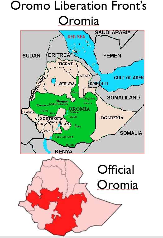
The Kurds, who number some 30 million, are often describes as the world’s largest nation without a state of their own. They have also often been depicted as a “forgotten people,” generally overlooked by the global media. Yet the Oromo of Ethiopia and environs also number some 30 million, and they too have national aspiration. And if the Kurds have been “forgotten,” how might one characterize the Oromo?: “Never noticed in the first place?”

Although the Oromo have been granted a supposedly autonomous region in Ethiopia, Oromo nationalists demand independence. They also want additional territory. As can be seen in the maps above, the territorial claims of the Oromo Liberation Front are substantially larger than Ethiopia’s actual Oromia region. Thus even if Ethiopia were to grant Oromia independence (admittedly, an all but unthinkable occurrence), the conflict would probably persist. Ethiopia’s granting of independence to Eritrea in 1992, after all, did not bring peace, as the two countries continued to struggle over border districts.

The Oromo Liberation Front (OLF) is officially classified by the Ethiopian government as a terrorist organization. The OLF itself, with office in Washington D.C. and Berlin, maintains that it is democratic and non-violent, dedicated to the peaceful self-determination of the Oromo people. Critics, however, charge the OLF with violent rebellion, targeting Amhara people in Oromo areas, and making common cause with Islamist radicals in Somalia.

If the Oromo Liberation Front is indeed a militant group, its status in the Unrecognized Nations and Peoples Organization (UNPO) could be jeopardized. UNPO (which has no connection with the UN) is an international organization dedicated to providing a political platform for self-proclaimed nations that remain under the domination of recognized states. Member organization must pledge to uphold democratic pluralism and non-violence. The Oromo Liberation Front has been a member since 2004.

The Unrecognized Nations and Peoples Organization had a fortuitous beginning. Initiated in Estonia in 1990, it gained additional support from Latvia, Georgia, Armenia and 11 other self-proclaimed nations without states. The collapse of the Soviet Union brought independence to four of the founding members the next year. Other groups joined, however, and the organization grew. It now boasts 54 active members: another five groups have been suspended, and 16 have withdrawn or been discontinued. Based in The Hague, the UNPO functions as a kind of para-United Nations, seeking a parallel path to international legitimacy for peoples excluded from the state-based international order.

The member organizations of the UNPO make unusual bedfellows. They include everything from the Tibetan Government in Exile to actually independent governments that have been denied international recognition (Somaliland), to European cultural groups that ended up on the wrong side of political boundaries (the former Danes of Southern Sweden), to small tribal federations such as the Tsimshian* of British Colombia, to the entire Aboriginal population of Australia (officially represented by the National Committee to Defend Black Rights), to the Afrikaans-speaking White population of South Africa. The organization’s position on the Afrikaner group is unambiguous: “The UNPO promotes the participation of the Freedom Front Plus within the democratic framework of South Africa, and recognizes the need of the Afrikaners to politically defend their linguistic and cultural rights. The UNPO further believes in the importance for all South African minorities, including the Afrikaners, to peacefully coexist in the ethnically varied context of South Africa, reiterating UNPO’s condemnation of any discrimination and targeted violence that takes place against the Afrikaners or any of the other ethnic minorities in the country.”

*The 10,000 members of this federation are divided into the following ethnic groups: Gidzalaal, Ginaxangiik, Gisp’axlo’ots, Gitandoyks, Gitlan, Gilutsau, Gitwilgyots, Git’andoo, Git’tsiis, Gitga’ata, Gitxaa³a, Gitasoo, Gitsalasuu and Gitsumgel’m.

The Oromo and the Unrecognized Nations and Peoples Organization Read More »

The Knights of Malta: Sovereignty without Territory


The global political system is founded upon the idea of sovereignty, defined by the Wikipedia as “the quality of having supreme, independent authority over a territory.” The independent countries that make up the geopolitical order are all purportedly sovereign entities, exercising complete power over their territorial domains. Such domains need not be large. Luxembourg is sometimes regarded as an almost comically small country (999 square miles), but it is a giant compared with Lichtenstein (62 square miles), which is a giant compared to Monaco (0.76 square miles), which is a giant compared to the Vatican City (0.17 square miles) – a walled-off collection of buildings in Rome. But at least the Vatican has a domain. The Sovereign Military Order of Malta has no territory at all, unless one counts the two buildings in Rome in which it enjoys extraterritorial legal privileges. Yet the Knights of Malta, as the organization’s official name denotes, is widely regarded as a sovereign entity, recognized as such by the 104 countries with which it maintains diplomatic ties (see map).

The Order’s international status, simply put, contradicts the standard definition of sovereignty. If the Knights of Malta have sovereignty, sovereignty does not denote the exercise of ultimate power over a place, but rather merely the acceptance into the club of ultimate powers, most of which are territorially based. In that case, I see no reason why an individual could not be regarded as a sovereign entity, as in Neal Stephenson’s novel Snow Crash (one of whose characters backed up his personal sovereignty with nuclear weapons).

Like the sovereign states of Monaco, Lichtenstein, Andorra, and San Marino, the Military Order of Malta is best regarded as a feudal remnant that somehow managed to escape Europe’s geopolitical modernization. Originating from the crusading order of the Knights Hospitaller of Jerusalem, it held the territorial domain of Malta from 1530 to 1798. Expelled from the island by Napoleon, it reestablished itself as a military-medical organization in Rome while holding on to its sovereign status. It has also retained a good measure of its feudal structure; until the 1990s, its officers had to be of noble birth. According to some sources, it has transformed itself over the past few decades from an exclusive, semi-monastic organization obsessed with genealogy to an effective, if idiosyncratic, humanitarian agency.

The Military Order of Malta may not control any territory, but it does have many of the trappings of sovereignty. Besides exchanging embassies with actual countries, it issues its own passports, postage stamps, and currency, although the latter two are largely collectors’ items. It also has its own military corps, which, like the order as a whole, is now largely devoted to international medical service.

The Knights of Malta are occasionally mentioned in the press for their humanitarian endeavors, most recently in Haiti. They have also been working in Lampedusa, a small Italian island between Sicily and Tunisia that serves as a detention center for asylum-seekers and other would-be immigrants to Italy.

The Knights of Malta: Sovereignty without Territory Read More »

How Many Continents Are There?

How many continents are there?Zealandia, New Caledonia

The main problem with the continental scheme of world division is its mixture of physical geographical criteria (continents are defined as landmasses more or less separated from each other by waterways) with human geographical criteria (Europe is separated from Asia not by the physical landscape but by historical and cultural features). Intellectual coherence calls for one basis of division or the other. When human features are favored, the continental architecture vanishes altogether as North Africa joins the quasi-continent of the “Middle East,” while Latin America links southern North America with South America. Continents are thus essentially regions of physical geography, and should be defined accordingly.

But the standard physical definition of continents remains problematic, as the “more or less” formulation allows conceptual slippage. In much of the world, North and South America are viewed as a single continent, since they are clearly connected by the Panamanian isthmus. But by the same criterion, Eurasia and Africa would also have to be regarded as a single continent, Afroeurasia. And if one takes a long historical perspective, the Americas and Afroeurasia together form a single super-landmass. They are not separated by deep water, and they have been periodically joined together over the past few hundred thousand years; when the world goes into a glacial period, sea levels drop and the vast plains of Beringia emerge to link the two lands. When Beringia appears, temperate and arctic animals migrate between the continents. As a result, the fauna of temperate North America and Eurasia are remarkably similar. Even during non-glacial periods the circum-polar region forms a zone of inter-continental linkage, as is clearly visible on the Dymaxion projection map above.

A strict physical definition would thus hold continents to be landmasses enduringly separated from other landmasses by relatively deep waterways. If one employs this scheme of division, a very different map of the world emerges, one dominated by a mega-continent that we might call Amerafroeurasia, or simply “The World Continent.” This landmass is divided into the macro-continents of the Americas and Afroeurasia, which in turn are split into the “continentoids” of North America, South America, Eurasia, and Africa (the term “continentoid” indicates that these lands are not actually separated by water). A third order division of the world continent separates associated large islands and island groups, most of which are joined with the landmass during glacial periods.

Clearly separated from Amerafroeurasia are the meso-continents of Australia (including New Guinea) and Antarctica, which have not been connected to other lands for millions of years. As a result of such separation, Australia has a highly distinctive fauna. By the same token, Madagascar and New Zealand may be considered micro-continents. Focusing in still more closely, one may even distinguish nano-continents, such as New Caledonia. A nano-continent is distinguished from a mere oceanic island (such as Hawaii) by the fact that it is composed of continental crust that long ago hived off from a larger landmass. Alternatively, both New Caledonia and New Zealand can be regarded as fragments of the largely submerged meso-continent of Zealandia (see map above).

How Many Continents Are There? Read More »

Nonsense about Continents


Basic geographical education in the United States remains, in a word, pathetic. As students are required to learn virtually nothing about the world, we should not be surprised that few young Americans have any idea where Iraq or Afghanistan are located. And the one locational lesson in global geography that young students are required to master, that of the “seven continents,” is, in a word, nonsense. The absurdity of the continental framework is readily apparent in a lesson plan found on the My Schoolhouse website, a prominent educational resource. The page begins by informing students that, “the seven continents are North America, South America, Europe, Asia, Africa, Australia, and Antarctica.” But the map placed immediately below this assertion (see above) portrays Central America, the Middle East, and Greenland exactly as they do North America, Africa, and the other supposed continents. True irrationality comes with a question listed below the map: “What continent appears to be part of Asia?” But “Europe” and “Asia,” along with “Middle East,” appear on this map merely as labels attached to different areas of a single landmass. As such, students could just as easily deduce that “Asia appears to be part of Europe.”

Nonsense about the supposed continents extends well beyond elementary education. My favorite absurdity comes with the mountaineering quest to bag the “seven summits,” defined as the highest peaks on each of the world’s continents. The list includes some formidable peaks – but it also takes in Australia’s Mount Kosciuszko, a gentle rise that one could surmount on a bicycle, if only authorities would allow it. To be sure, Reinhold Messner proposed dropping Kosciuszko in favor of New Guinea’s Puncak Jaya, which is indeed a difficult climb. By any reasonable standard, Messner was absolutely correct: New Guinea is part of the same piece of continental crust as Australia (see map), and is thus by continental criteria as much part of Australia as Japan is part of Asia. But despite Messner’s fame – and demands of reason – Kosciuszko remains standard.

So what is the actual continental architecture of the world? That issue will be addressed in tomorrow’s post.

Nonsense about Continents Read More »

Militias, Private Armies, and Failed States


Max Weber famously defined the modern state as an entity claiming a monopoly on the legitimate use of violence to enforce order over a specific territory. By this definition, many of the countries that constitute the international geopolitical order fall well short of being genuine states. Consider Lebanon. From 1976 to 2005, a sizable Syrian army was parked on Lebanese soil, making a mockery of any claims that the Lebanese state had a monopoly on force. Although that army subsequently withdrew, Lebanon was not able to establish sovereignty over the full extent of its territory. It is generally agreed today that Hezbollah’s Islamist militia is stronger than the Lebanese national army, exercising power if not monopolizing violence in the country’s Shiite-majority areas, and thereby compromising Lebanon’s territorial integrity if not its very statehood. By strict Weberian criteria, Lebanon must be regarded as a semi-fictive state, one that has the forms but not the full powers of genuine statehood.

One could argue that Hezbollah, for all its strength, is an illegitimate wielder of violence, making Lebanon a legitimate if beleaguered state. Elsewhere in the world, however, plenty of more ambiguous cases can be found. Some states allow the proliferation of private armies, granting paramilitary groups a form of legitimacy—and in so doing undermining their own. If a country takes the further step of relying on such autonomous purveyors of violence to uphold its own order over large stretches of its supposed territory, then it can no longer be classified as a fully modern state, at least by Weber’s definition. Instead, it should be regarded as something more akin to a feudal entity, one in which effective sovereignty is diffuse and parcelized, ceded by a theoretically sovereign power to largely independent, localized forces.

Such quasi-feudal states are more widespread than is commonly realized. Consider the Philippines, the world’s twelfth most populous country. By certain criteria, the Philippines is relatively stable; according to the Failed States Index, more than fifty other countries are at greater risk of systematic collapse. Yet private armies operating with impunity have long been a staple feature of Philippine political life. As MindaNews reported on February 5, 2010, fifty-two private militias operate on the island of Mindanao alone. The power and audacity of Philippine armed retinues came to global attention after the Maguindanao Massacre of November 2009. Fighters associated with the powerful Ampatuan clan attacked a convoy of a rival clan that was heading to register one of its members as a candidate for an up-coming gubernatorial election; fifty-one people were slaughtered, including as many as 32 journalists. The Committee to Protect Journalists describes the incident as the largest single attack on news-reporters in world history.

The November massacre was so outrageous that the Philippine government had to react, arresting key members of the Ampatuan clan, conducting raids (one of which netted 330,000 rounds of M-16 ammunition), and declaring martial law in the region – in effect, denying the legitimacy of the private army that had perpetuated the bloodbath. But up to that point, the Ampatuans had been key allies of the government, and had in fact helped engineer the presidential election of Gloria Macapagal-Arroyo in 2004 by ensuring her virtually all of the vote in their home district. Elsewhere in the Philippines, private armies continue to operate with impunity, periodically serving state ends by battling Islamists insurgents in the south and the forces of the Maoist New Peoples’ Army through the rest of Philippine archipelago.

States are by definition territorial entities that are supposed to exercise control over the all areas within their internationally sanctified borders. In the Philippines, as in many other countries, such a condition remains more a dream than a reality. As the map above shows, most parts of the archipelago remain vulnerable to insurgent forces, which retain effective control over many remote areas. Philippine territoriality in the south is also complicated by the existence of the Autonomous Region of Muslim Mindanao, a topic that will be addressed in next Monday’s posting.

Militias, Private Armies, and Failed States Read More »

The Republic of Hau Pakumoto?


The globe-spanning European empires of the 1800s were essentially dismantled in the decades following World War II, with one important exception. In the maritime realm, empire lingers in the form of continuing colonial control over small oceanic islands, some inhabited, others not. If one includes the 200 nautical-mile exclusive economic zones that sovereign states control around their island holdings, such oceanic “empires” cover a substantial portion of the earth’s surface. As the map reproduced above shows, France’s maritime sphere is vast and far-flung, giving France a truly global reach.

France governs its various insular and oceanic territories in different ways. Some of its islands (Reunion, Guadeloupe, and Martinique) are integral units of the country, as much parts of France as Hawaii is part of the United States. Most others are organized as “overseas collectivities,” ruled in a more colonial manner. The sizable and resource-rich island of New Caledonia, however, is classified as a “sui generis collectivity”; its ties to France are structured in a unique and particularly complex manner.

While France undoubtedly exploited its colonial domains, today its vestiges of empire are more consistently subsidized. Such revenue flows, however, do not prevent chafing against the existing regime. Independence movements and other organized forms of resistance are found in most of the inhabited islands ruled by France, even Corsica. In February 2009, protests in Guadeloupe and Martinique turned deadly, forcing Paris to send in police reinforcements. Focused mostly at the high cost of living, the protests also targeted the domination of local economies by metropolitan elements.

French Polynesia, a vast oceanic expanse containing some 264,000 inhabitants, has also given France major headaches in recent years. Since 2004, this “overseas collectivity” has experienced nine changes in government, prompting Nicholas Sarkozy to describe the situation as “comical.” Pro-independence and pro-France local politicians struggle against each other, but then often join forces to direct subsidies to their own islands. Denunciations of Chinese merchants, followed by denunciations of such denunciations, are another stable feature of French Polynesian politics. As instability has increased, Paris has looked for possible reforms. In January 2010, Sarkozy proposed revamping the colony’s electoral system, but received little local support.

As is true in the French Caribbean, much of the popular discontent in French Polynesia stems from the high cost of living. Such tensions reached a climax on January 19, 2010, when opposition leaders on the island of Moorea – a favored tourist destination – publically seceded from France and French Polynesia, declaring that henceforth Moorea should be regarded as the independent republic of Hau Pakumoto. Although the announcement appears to have been largely a publicity stunt, French officials took it seriously, seizing funds and illegally issued identity cards. According to the Vancouver Sun, the minister of international affairs of the new “republic” claimed that more then 50,000 people support independence, a suspiciously high number considering the fact that Moorea’s population is only about 16,000.


The Republic of Hau Pakumoto? Read More »

Maps and Stats, Good and Bad

World thematic maps that treat each country as a holistic entity can be highly misleading. Consider, for example, the ubiquitous economic development map based on per capita gross domestic product. Here we see such countries as Brazil, India, and China uniformly colored, as if the goods and services they produced were evenly distributed over their vast expanses. In actuality, per capita GDP varies by roughly an order of magnitude from the wealthier to the poorer regions of each of these countries. More finely subdivided maps are much more revealing, but they can also be hard to find. In the case of the European Union, fortunately, a treasure trove of regionally specific maps is available from the European Commission Eurostat website: http://epp.eurostat.ec.europa.eu/statistics_explained/index.php/Category:RegionsEuropean.

On the Eurostat map reproduced above, a number of significant spatial patterns jump to the eye. Notice how Prague stands out from the rest of the Czech Republic, and how Athens is differentiated from the rest of Greece. The north-division in Italy is clearly apparent, as is the gap between the prosperous south of Germany and its poorer northeastern counterpart. This is just one of many detailed maps available at the Eurostat site, which delves into social as well as economic issues. The map of internet usage is especially noteworthy, revealing as it does a substantial cultural divide between what we might call the networked north and the sociable south.

To be sure, maps based on country-level data can also be valuable, especially for those parts of the world divided into relatively small countries. Such maps cease to be useful, however, when dubious data is employed – as happens all too often. The worst single example that I have come across is a NationMaster map of per capita crime rates, reproduced above. A glance at the key reveals that this map identifies Finland and New Zealand as crime-ridden, while Colombia, Yemen, and Papua New Guinea are portrayed as practically crime free. The accompanying table gives Yemen an absurdly low (and surreally precise) rate of 1.16109 crimes per 1,000 people. Finland, we told on the same page, suffers a crime rate roughly two orders of magnitude greater, at 101.526 per 1,000 people

(http://www.nationmaster.com/graph/cri_tot_cri_percap-crime-total-crimes-per-capita). Similar problems are encountered elsewhere on NationMaster, a site that compiles a huge array of official statistics. The figures for rape rates, for instance, listed on the home page as one of the site’s “top stats,” ranks Saudi Arabia as the safest country for women while marking Australia as the third-worst with Canada close behind.

Could anyone serious believe that a woman is 250 times more likely to be raped in Australia than in Saudi Arabia? — or that Finland’s overall crime rate is 100 times that of Yemen? Finland is famous for its relatively crime-free environment; Yemen is a land of anarchic clan-based violence and rampant kidnapping. In Finland, however, most infractions are reported and recorded, whereas in Yemen few crimes reach official attention. If NationMaster labeled its map and chart “rate of reported and recorded crimes,” it would be an accurate and useful index of police efficiency, if not of criminal activity. But it does not. Does anyone at NationMaster scrutinize the data that is displayed on its site? Does anyone care?

Underlying the promulgation of such misleading maps is our tendency to take the sovereign state for granted: to treat all recognized countries as if they were equivalent entities with comparable governmental capacities, including the gathering and compiling of accurate statistics. This is not the case. And as far as statistics themselves are concerned, we should recall Mark Twain’s warning: many stats are lies, some damned, other worse.

Maps and Stats, Good and Bad Read More »