
Not surprisingly, the distribution of oil and natural gas provides one of the main explanations of Iran’s spatial pattern of economic productivity. As noted in the previous post, the coastal provinces of southwestern Iran post some of the highest production figures relative to population in the country. According to official Iranian data from 2020, the per capita GDP of Bushehr was more than twice that of the country’s second-ranked province. As can be seen on the paired maps below, Bushehr has a sizable share of Iran’s oil, and an even larger portion of its natural gas. It also contains Kharg Island, which exports around 90 percent of Iran’s oil products.


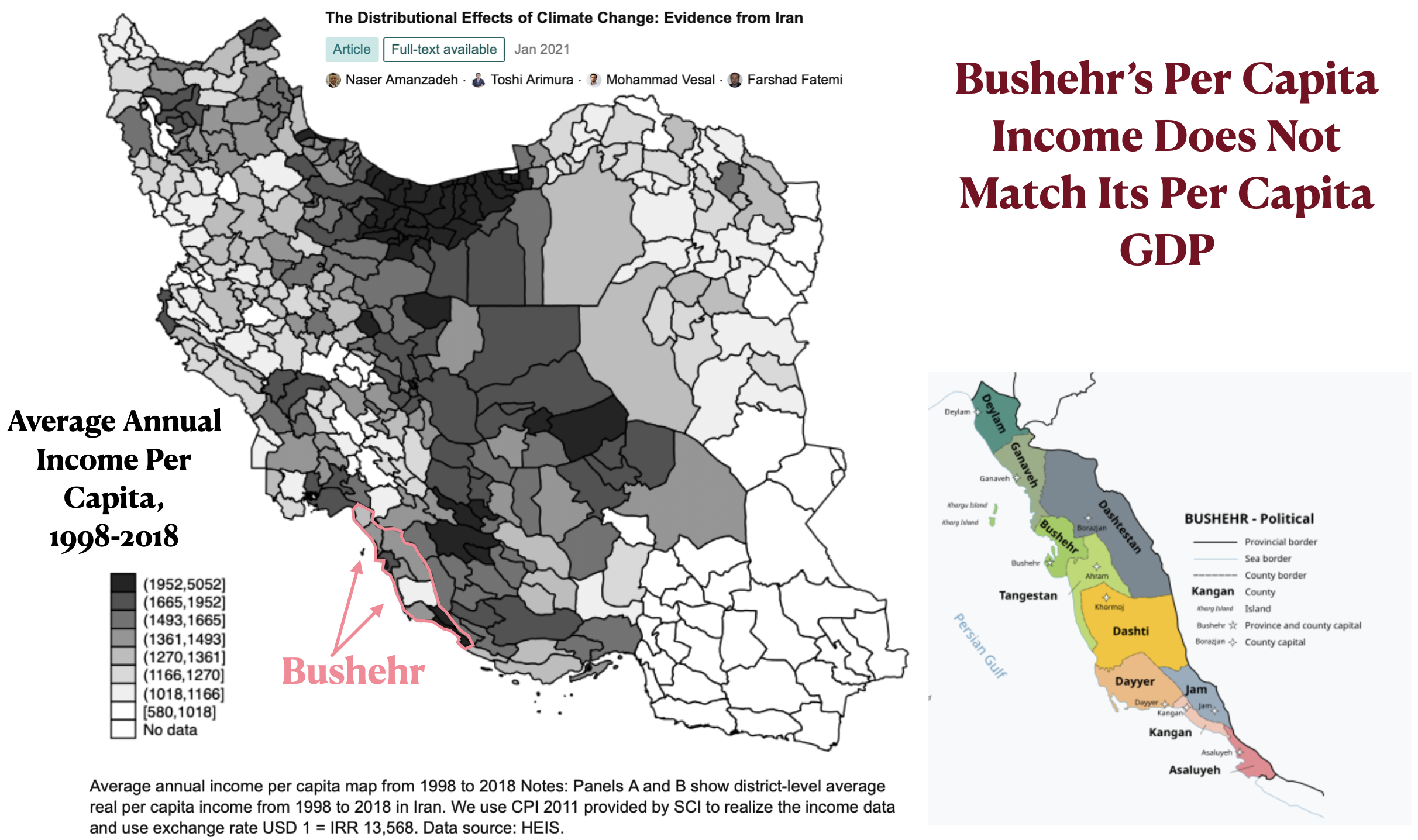
But if the map posted below can be trusted and is still accurate, per capita income in Bushehr does match the province’s economic productivity. This is also not surprising, as the main benefits of natural-resource extraction often flow out of the resource-endowed regions. But as can also be seen on this map, the three southernmost counties of Bushehr – Jam, Kangan, and Asaluyeh – had some of the country’s highest average-income figures from 1998 to 2018. They almost certainly still do. Located here is massive Kangan Gas Field and, more important, the “Kangan Ethane Recovery & Cracker Plant – Kangan Petro Refinery.” As the Wikipedia article on Jam County notes, “The fast-growing city of Jam … is home to workers at the nearby … Kangan industrial complex [and] is growing exponentially and affluently.” More surprisingly, the same article goes on to claim that “most of the workers in the city, and on the farms and gardens around the city, are Afghan migrant workers.” I doubt that Afghan migrants are receiving a sizable share of whatever affluence the region enjoys.
The geography of oil in Iran also explains the anomalously high per capita GDP of Kohgiluyeh and Boyer-Ahmad province found in some datasets (see the previous GeoCurrents post). As the per capita income map indicates, this small and mountainous province was relatively poor up to 2018. It probably still is. Artificial Intelligence (Grok) tells me that “Multiple studies group KBA [Kohgiluyeh and Boyer-Ahmad] with provinces facing disadvantages in employment participation, entrepreneurship, rural poverty, and overall opportunities.” But Grok also claims that “The province holds about 13% of Iran’s total oil reserves and it contains 8 oil fields. … Recent government investments (e.g., €260 million planned for boosting output by 40,000 barrels/day) underscores its strategic role.” Kohgiluyeh and Boyer-Ahmad thus seems to be a resource-rich province that has recently experienced substantial extractive investments without experiencing proportional economic development. Globally speaking, this is not an uncommon situation.

The oil map of Iran posted above also shows significant fields in Lorestan, another relatively poor province. Lorestan oil production, however, remains modest. According to AI, large shale oil deposits have recently been discovered in the province, but they are not economically viable at this time.