Economic Geography

Mapping zones of wealth and poverty; illustrating the global geography of economic development

Migration and Diplomatic Tensions In Costa Rica

Nicaragua, the poorest country in continental North America by a good margin, sends immigrants not only northward into Mexico and the United States but also southward into Costa Rica. The economic disparity along Nicaragua’s lightly policed southern border is steep and Costa Rica, unlike Nicaragua, is known for its political stability, effective government, and high levels of social well-being. Nicaraguans have been moving south for some time, the flow accelerating with every natural and political disaster at home. Most estimates put the number of people of Nicaraguan origin in Costa Rica at about 10 percent of the total population; roughly half are undocumented.

Costa Ricans tend to disparage “Nicas,” blaming them for crime and stressed social services. In 2005, the mauling death of a suspected Nicaraguan thief by two dogs generated a diplomatic episode. Reports claimed that Costa Rican bystanders, including members of the police, simply watched as the animals ripped the man apart. A few hard-core Costa Rican nationalists defended the attack. The Inter-American Commission on Human Rights report on the incident is worth quoting at length:

“According to the State of Nicaragua, ‘in certain sectors there has arisen a marked climate of verbal violence, intolerance, and xenophobia as is apparent from publications produced by groups interested in stirring up hate and even violence against Nicaraguans in Costa Rica.’ … [I]n the days following the death of Mr. Canda Mairena a number of ‘jokes’ and xenophobic displays appeared on different Internet web sites … An electronic mail message dated November 11, 2005 says, ‘Due to the recent events of bravery and heroism that showed that the dog is the Costa Rican’s best friend (today more than ever), all of the below signed wish to present to the legislative assembly a bill to change the yiguirro [the national bird of Costa Rica] thanks to the heroic dogs Oso and Hunter “Rottweller” (sic), who took the initiative, cast fear aside, and redefined Costa Rican culture and valor against the invasion of the neighbors to the north.’”

In 2006, Costa Rica implemented a stringent immigration reform. As reported in the Los Angeles Times, “Costa Rica’s new immigration law is aimed largely at those who profit from undocumented workers. It makes human trafficking a crime punishable by as much as six years in prison. And it significantly increases fines on Costa Ricans caught employing illegal immigrants — to $3,600 per violation, up from as little as $10…”

Costa Rica’s current immigration news story concerns China rather than Nicaragua. Some 600 Chinese workers recently came to Costa Rica to work on a new national sports stadium, financed by Beijing as a favor for Costa Rica dropping Taiwanese recognition in 2007. As Chinese construction firms subsequently moved on to build an apartment complex in San Jose, the call went out for more Chinese workers. Costa Rica’s Ministry of Labor countered that there are plenty of qualified Costa Ricans who could be employed instead. On June 27, 2010, Costa Rica’s ambassador to Beijing lodged an official protest against Chinese pressure on his country to allow in the additional workers.

Many Costa Ricans are apparently irritated with China. As one commenter put it, “With roughly 1.5 billion people the next thing will be the waters being over-fished and no sharks anywhere to be found, which is already happening anyway. All for a free stadium. … Time to tell them ‘a Dios muchaco’, and apologize to/make friends again with the Taiwanese, who were generous without all of the strings attached.”

Migration and Diplomatic Tensions In Costa Rica Read More »

Regional Economic Disparities and Migration in Mexico


On the global scale, Mexico is a middle-income country, a fact lost on most Americans. According to the IMF, it ranks 60 out of 184 in per capita Gross Domestic Product. Measured in purchasing power parity (PPP), Mexico produces roughly $13,600* worth of goods and services per person per year, a figure comparable to those of Malaysia, Lebanon, and Turkey. While substantially lower than that of the United States ($46,300), much less than those of Luxembourg ($78,300) or Qatar ($83,800), Mexico’s per person output towers over those of truly destitute countries, such as Zimbabwe ($355) or the Democratic Republic of Congo ($332). (Per capita GDP, as discussed previously in Geocurrents, is a vexed measurement of wealth and poverty, but it does give a general sense of economic development.)

Mexico’s economic output varies substantially from one region to another. The country’s wealthiest subdivision, the Federal District, produces more than six times the value of goods and services per capita as the poorest state, Chiapas. The basic geographical pattern is one of relative prosperity in much of the core area of Mexico City and through most of the north, coupled with much lower levels of economic activity in the south, particularly in the states of Chiapas, Oaxaca, and Guerrero. But even Mexico’s poorest states are relatively well off when compared with nearby countries further to the south; the per capita GDP of Chiapas is more than three times larger than that of Nicaragua. Overall, Mexico’s economic figures are comparable to those of Central and Eastern Europe, as is evident in the chart posted just below (the chart takes a sampling of Mexican states, ranging from the richest to the poorest, and pairs them with European countries of roughly equal output).

Relatively high per capita GDP can coexist with widespread poverty if income distribution is highly skewed or if profits are monopolized by groups from outside of the region. Such a disconnection between per capita GDP and basic economic wellbeing is especially notable in two Mexican states, Quintana Roo and Campeche, both located on the Yucatan Peninsula. These states have an elevated rank in regard to both economic production and, as is evident in the 2000 CIMMYT maps posted above, deprivation. The explanation seems to lie in the states’ particular patterns of economic development. Quintana Roo has profited massively from the mega resorts of the Cancun area, but the fruits of such development had not spread widely by the year 2000. The same seems to be true in regard to the profits flowing from the oil industry of Campeche. It would be interesting to see the extent of poverty reduction in these two states over the past ten years.

Because Mexico is so much more prosperous than its southern neighbors, it attracts large numbers of Central American immigrants, most of them arriving illegally. As a 2008 WorldFocus article reported, “According to Mexico’s National Institute of Migration, 2 million documented and undocumented cross Mexico’s southern border a year. The majority of these undocumented immigrants are Guatemaltecos, followed by Hondurans, Salvadorians, and … Nicaraguans.” Many of these immigrants are ultimately headed to the United States, but a substantial number seek work in Mexico, much closer to home. Mexico has often treated its own undocumented workers harshly. In late June 2010, the Mexican government announced a new program, dubbed “Summer 2010,” designed to increase patrols along both its northern and southern boundaries, but also to provide humanitarian assistance for would-be border-jumpers. According to a recent article, “during this special summer operation, immigration officials will try to dissuade migrants from continuing their journey, insofar as they will be exposed to dehydration due to long walks in temperatures of more than 40 degrees Celsius [104 °F].

*In nominal terms (measured in currency equivalents rather than purchasing power), Mexico’s per capita GDP is only about $8,100, but it still ranks 61 out of 181 countries, Quintana Roo, Campeche

Regional Economic Disparities and Migration in Mexico Read More »

Misconceptions About Mexico’s Birth Rate


In the American immigration debate, the point is often made on talk radio that Mexicans stream into the United States because their birth rate is so high. Mainstream sources sometimes make the same argument. In June, 2010, Britain’s Prince Charles warnedabout the “cultural pressures that keep the global birth rate high,” arguing that the same is true in “Mumbai, Cairo or Mexico City; wherever you look, the world’s population is increasing fast.”

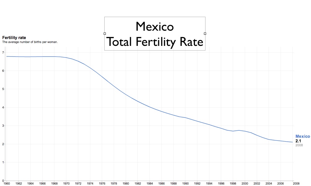
The population of Mexico City is certainly increasing, but not because the country’s birth rate is elevated. Mexico’s total fertility rate (TFR), or the number of children born to an average woman, is actually very close to 2.1—essentially the same as that of the United States. If Mexico’s population continues to expand, it is because its fertility drop is so recent. At its current birth rate, the Mexican population will soon stabilize even without emigration to the United States. As a developing country, Mexico is hardly alone in this situation. Mauritius’s TFR is 1.9, Thailand’s is 1.8, and Trinidad and Tobago’s is 1.6, all well below replacement level.

In Mexico, fertility patterns vary significantly from state to state, as is to be expected. The map that I have constructed above using demographic data from the 2000 census shows a distinct regional pattern, with relatively high fertility rates in the south contrasting sharply with lower rates in both the north and center (including greater Mexico City). The correlation with socio-economic development is marked, as is made clear by comparing this map with that of Mexico’s Human Development Index. But even Mexico’s least developed states have relatively low birth rates by historical and global standards, with only Guerrero exceeding 3.0 in 2000.

Urbanization as well as development correlates with reduced fertility. Consider the state of Mexico, the country’s most populous political subdivision, with more than 14 million inhabitants. This state encompasses many of the poorer parts of Greater Mexico City, and thus has a per capita level of economic output substantially lower the national average ($8,900 for the country of Mexico vs. $6,200 for the state of Mexico, in nominal GDP). Yet the state’s birthrate is well below the national average, having been under the replacement level even in 2000. The state of Mexico also sends a disproportionate number of emigrants to the United States, “making up about 75.7% of the total Mexican population that migrates,”according to the unsupported figures given in the Wikipedia. (Intriguingly, Mexican-Americans have significantly higher birth rates than Mexicans. In 2007, Hispanics in general in the United States had a TFR of 2.9 in 2007, as compared to 2.1 for blacks, 1.9 for Asians, and 1.86 for whites.)

At the global scale as well, Prince Charles’s insinuation that contemporary urban surges in the Third World result from elevated birthrates is misleading. Cities have fed on migration from the countryside since the dawn of urbanization 5,000 years ago; before the 1800s, death rates in urban areas almost always exceeded birth rates. Although modern methods of hygiene now allow cities to sustain themselves, urban fertility rates usually remain substantially lower than rural fertility rates. If global demographic stabilization is the goal, one should champion rather than disparage urbanization. Of course there are other grounds for opposing the further expansion of such megacities as Mumbai, Cairo, or Mexico City, but urban population growth should not blind us to the dramatic downward shift in many developing countries’ overall reproductive rates.

Misconceptions About Mexico’s Birth Rate Read More »

South Korea’s Shifting Economic Geography


South Korea is conventionally divided into three main regions: a dominant northwest (greater Seoul); a prosperous, conservative, and politically favored southeast; and an underdeveloped, disgruntled, and left-leaning southwest. Recent economic data, however, reveals more complicated geographical patterns. South Korea’s economic advance over the past few decades has evidently begun to unsettle its ancient tripartite division.

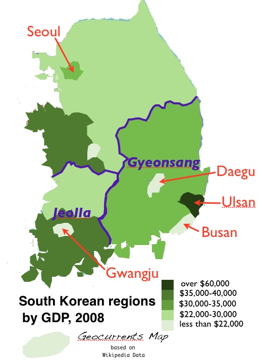
In terms of per capita income, the old patterns are still evident; Seoul is the wealthiest region of South Korea, with Ulsan and South Gyongsang (Gyeongsangnam-do or Gyeongnam) in the southeast coming in second and third. But when it comes to economic production as measured by per capita GDP,* a different map appears. Here South Korean economic development seems relatively evenly balanced; the southwest (Jeolla/Honam) does not appear underdeveloped, while the supposedly privileged Southeast (Gyeonsang) has the lowest as well as the highest levels of output. Seoul is demoted from first place, outclassed not only by Ulsan in the southeast but also by Jeollanam-do (South Jeolla, Jeonnam) in the allegedly marginalized southwest. More astounding is the last-place showing of Daegu, the seat of the old-guard political establishment. Southeastern Busan (Pusan), South Korea’s second largest metro area and the site of the world’s fifth largest port, also ranks surprisingly low.

Overall, South Korea exhibits pronounced variation in regional economic output. On a per capita basis, Ulsan produces 3.6 times more goods and services than does its near-neighbor Daegu, both of which are located in the Gyeonsang region. Regional economic disparities in other technologically advanced countries tend to be less pronounced. In the United States, for example, Connecticut produces not quite twice the economic output per person of Mississippi ($56,000 vs. $29,600). Developing countries, in contrast, often show extreme variation. In Brazil, São Paulo out-produces Piauí by a factor of five; in India, Goa’s per capita GDP outranks that of Bihar by almost an order of magnitude.

The huge gap between Ulsan and Daegu is rooted in the changing fortunes of their main industries. Nicknamed “the textile city,” Daegu thrived when low-wage South Korea profited from massive exports of inexpensive clothing and fabric. But as South Korea climbed the value ladder, it ceased to be internationally competitive in mass-market textiles. As the industry declined, so did Daegu, both economically and demographically. Since the late 1990s, city leaders have pushed high fashion, hoping to emulate Milan, but evidently with little success. Ulsan, in contrast, has prospered from South Korea’s export boom in transportation equipment. Headquarters of Hyundai, and site of the world’s largest shipyard, oil refinery, and automobile factory, Ulsan produces more goods and services on a per capita basis than all but about three or four countries, outpacing the United States by a comfortable margin ($63,800 vs. $46,000).

Although it is relatively easy to explain the discrepancy between Ulsan and Daegu, other patterns on the South Korean regional GDP map seem more perplexing. Why does South Jeolla exhibit such high levels of economic productivity yet maintain a reputation for marginalization? If any Geocurrents readers can help explicate the South Korean GDP map, I invite them to do so!

Although per capita GDP is the most commonly employed metric for economic standing, it is a flawed indicator, especially at the sub-national level. An area can generate high levels of value, yet lose much of the resulting income stream to other places. By the same token, places of concentrated political power can maintain higher levels of per capita income than their GDP figures would indicate.

GDP is coming under increased criticism, but largely because it ignores environmental degradation and non-financial aspects of social development and human satisfaction. Last fall, French President Nicolas Sarkozy “called for a ‘great revolution’ in the way national wealth is measured today, throwing his weight behind a report which criticises ‘GDP fetishism’ and prioritises quality of life over financial growth.” But even if one focuses exclusively on economic issues, GDP figures often paint a misleading picture. Among other things, they can vary tremendously depending on whether they are measured in nominal or purchasing power parity (PPP) terms; thus China has the world’s third largest economy by one measure (nominal GDP), and the second largest by another (PPP GDP). In the end, GDP does not measure “wealth” any more than it does happiness. All that one can conclusively say, as the Wikipedia puts it, is that Gross Domestic Product “is often positively correlated with the standard of living.”

* Gross Domestic Product, the total value of goods and services produced annually.

South Korea’s Shifting Economic Geography Read More »

South Korea is Divided Into Three Parts

“In South Korea …, the North’s human rights abuses are routinely shrugged off with reference to its supposed superior nationalist credentials. … Sympathy for Pyongyang is especially widespread in the peninsula’s chronically disgruntled southwest.”

– B. R. Myers, “South Korea’s Collective Shrug.” The New York Times, May 28, 2010.

Nationalism and regionalism often seem to be contrary phenomena. Countries with strong regional identities and stark regional disparities tend to have weak national foundations. But nation and region do not always counteract each other. South Korea in particular is characterized by both deeply rooted regionalism and intense nationalism.

Korean nationalism has evolved into different variants in the North and South. Under Pyongyang, the enforced cult of patriotism has veered in the biological direction of classical fascism, emphasizing the racial purity of the Korean – and especially the North Korean – people (see R.B. Myers, The Cleanest Race: How North Koreans See Themselves and Why It Matters). South Korean nationalism is much more cultural and historical, and thus accommodates streams of foreigners marrying into the Korean population. More than 5,000 Vietnamese women immigrate every year, generating some cultural tensions to be sure, but helping to maintain otherwise depopulating rural areas.

Despite its intensity, South Korean nationalism has by no means erased the country’s regional distinctions. South Korea’s basic divisions are often said to date back to the Three Kingdoms period (57 BCE to 668 CE), when the peninsula was divided between Silla, Baekje, and Goguryeo (Gaya, seen on the map, was not nearly as significant as the other three.). In the 600s, Silla, based in the southeastern part of the peninsula, unified the country. After Silla collapsed in the 900s, Goguryeo, based in what is now North Korea and northern South Korea, reunified the peninsula. Goguryeo was eventually supplanted by the Joseon Dynasty (or Chosun, 1392-1897), governed from Seoul. Baekje in the southwest, unlike the other two ancient kingdoms, never served as the hub of a unified Korea.

In modern South Korea, the southwest has been the focus of regionalist antipathy to the central government. Through the early decades of the postwar period, the region remained relatively poor and agrarian, its people suspecting that they had been intentionally marginalized by a hostile government. In 1980, the southwestern city of Gwangju rose up against the authoritarian South Korean regime, only to be crushed by the military. Official reports at the time linked the rebellion to a communist plot, but today it is officially commemorated as part of the national movement for democratization. A major breakthrough occurred in 1998, when a southwesterner, Kim Dae Jung – the “Nelson Mandela of Asia” – was elected to the presidency.

Since Kim left office in 2003, South Korea’s presidency has been filled by men originating in the southeast. Homeland of the former kingdom of Silla, the area known today as the Gyeongsang region has produced six of South Korea’s eight most recent presidents, including the incumbent, Lee Myung-bak. Critics claim that the conservative-leaning southeast receives undue favor from the central government, with infrastructural investments nurturing its industrial development. The city of Daegu is particularly noted for its political influence, being the seat of the powerful center-right Grand National Party.

Unlike the southeast and southwest, northern South Korea is not identifiable with an ancient kingdom, having been merely the southern portion of Goguryeo. But it was the site of the capital city, and it has remained the seat of political power. Development has continued to gravitate around Seoul and its greater metropolitan area – an hour’s drive from the North Korean border. Ten million people now live in Seoul itself, while more than 24 million – almost half of South Korea’s population – live in the officially demarcated National Capital Area. Northeastern South Korea, by contrast, is lightly populated (see map), and barely figures in discussions of South Korean regionalism.

South Korea’s basic geographical structure is thus conventionally conceptualized around a three-fold division: the northwest is the administrative, economic, and demographic core; the southeast is the prosperous heartland of the old-guard political establishment; and the southwest is a marginalized area of leftist politics. Electoral maps generally bear out this division. In 2007, Chung Dong-young of the left-liberal United New Democratic Party took the southwest, while Lee Myung-bak of the conservative GNP triumphed elsewhere, particularly in North Gyeongsang, the core area of the one-time kingdom of Silla.

But if the tripartite division of South Korea still obtains politically, it no longer does so economically, as tomorrow’s post will explore.

South Korea is Divided Into Three Parts Read More »

Struggles over Dams and Waterfalls in Paraguay


The uproar over Kathryn Bigelow’s plans to shoot a film in the Triple Frontier region (discussed yesterday) might seem surprising at first glance. Ciudad del Este and the tri-border zone are already known in Brazil, Argentina, and Paraguay for smuggling and crime, and are thus unlikely to suffer much domestically from American movie insults. Potential international tourists dissuadable by a grim film might seem too few to worry about; the Triple Border cities have scant attractions beyond the cheap electronics and cigarettes of Ciudad del Este. But the larger region does have one tourist draw of tremendous significance: Iguazu Falls (see photo). If the Triple Frontier gains notoriety as the result of a hit film by an acclaimed director, tourism revenues could drop.

Although by no means the highest drop, Iguazu is often ranked as the world’s most spectacular waterfall. Iguazu outranks Niagara, its nearest competitor, in two respects: it is higher (82 meters vs. 51) and wider (2,700 meters vs. 1,200). Since the Iguazu River has a more variable discharge than the Niagara, it also carries more water during peak seasons. And visitors can experience Iguazu more directly than they can Niagara. Iguazu’s intricate shape, along with its well-developed system of walkways, allows visitors to be enclosed by 260 degrees of plunging water.

Fifty-five years ago, Niagara and Iguazu ranked only third and fourth by flow rate,* but the world’s two biggest waterfalls have since gone extinct. The second largest, by a wide margin, was Celilo on the Columbia River between Oregon and Washington. Celilo’s drop was only seven meters – low enough for salmon to jump over – but it was still an impressive sight. The Dalles Dam, finished in 1957, inundated the falls, and in doing so evidently drowned the longest continually inhabited site in North America. Celilo Falls had been a premier salmon fishing location, with permanent settlements dating back some 15,000 years.

While Celilo was massive, it was dwarfed by Guaíra Falls on the Paraná River coursing between Brazil and Paraguay. Guaíra was the waterfalls of waterfalls, with seven distinct drops, the highest of which plunged 40 meters. The roar could be heard 20 miles away. But in the early 1980s, Guaíra disappeared behind Itaipu Dam. Just before that, its national park was disestablished and its rock faces were blasted away, due to fears that they might impede navigation during low water periods. Guaíra, unlike Celilo, is beyond resurrection.

Itaipu Dam itself is an impressive structure, deemed by the American Society of Civil Engineers one of the “seven modern wonders of the world.” Until the completion of China’s Three Gorges Dam, it was the largest hydroelectric power plant in the world, generating 19 percent of Brazil’s electrical power and 90 percent of Paraguay’s. In 1989, Philip Glass composed a symphonic cantata in honor of the dam, appropriately named “Itaipu.” (Glass’s symphony is not the only musical homage to a hydroelectric facility. Woody Guthrie, of all people, recorded another: “Well the world has seven wonders, the travelers always tell / Some gardens and some towers, I guess you know them well / But the greatest wonder is in Uncle Sam’s fair land / It’s that King Columbia River and the big Grand Coulee Dam.”)

Itaipu’s electricity is currently an item of contention between Paraguay and Brazil. Paraguay sells the bulk of its share to Brazil. Most Paraguayans think that the power is underpriced, owing to the cozy relations between their country’s historically dominant Colorado Party and the Brazilian government. Fernando Lugo won the presidency of Paraguay in 2008 in part by campaigning on a platform of “energy sovereignty.” Paraguay wants its annual compensation to increase from $120 million to $360 million. Brazilian president Lula da Silva agreed to the hike in 2009, but the deal is currently stalled in the Brazilian congress. Brazil’s business community is not pleased by the prospect, arguing that it “would have an impact on energy costs and consumers’ pockets.”

*Sometimes the cataracts on the Congo River are counted as the world’s largest waterfalls, but these are more properly classified as rapids.

Struggles over Dams and Waterfalls in Paraguay Read More »

Drug Wars in Paraguay

In early May 2010, Fernando Lugo, president of Paraguay, met with Brazilian president Luiz Inácio Lula da Silva in the Paraguayan border town of Pedro Juan Caballero, population 75,000. Security was heavy, as befitted the location. Pedro Juan Caballero is noted for its cheap electronics and deadly drug smugglers.

After wondering whether the border outpost was too dangerous for such a meeting, Lula concluded that “…we need to show ourselves here, because honest people outnumber the drug traffickers.” Outnumbered though they may be, the traffickers’ ranks are growing – and growing more violent. An average of eight dead bodies turn up in and around the town each month, prompting comparisons with Ciudad Juarez. Brazilian drug gangs appear to be responsible for the mounting bloodshed. According to one report,
“the largest criminal factions in São Paulo … have imported practices not carried out by Paraguayans such as the summary execution of enemies.” In April 2010, gang members shot Paraguayan Senator Roberto Acevedo, who had dared to criticize them, in the arm and face. Acevado survived; his driver and bodyguard did not.

The presidential summit in Pedro Juan Caballero covered severalissues. Paraguay insisted on discussing what it sees as unfavorable electricity contracts from the gargantuan Itaipú dam on the Paraná River. Brazil, for its part, wants president Lugo to pressure the Paraguayan Congress to allow Venezuela’s entry into Mercosur, the South American trade block. But the big topic was crime and its possible links with insurgency. The Paraguayan rebel group EPP is supposedly connected with both FARC, Colombia’s drug running revolutionary army, and the hyper-violent São Paulomafia. The governments of Paraguay and Brazil have much to fear in the specter of a Colombia-style narco-insurgency along their border.

Paraguay became a paraíso de contrabandistas, or smuggler’s paradise, during the long period when it was economically cut off from its neighbors. As a Mercosur member-state, it is now regionally well integrated, but old habits persist. Paraguay also has a relatively weak state apparatus, with a limited capacity for law enforcement. (Lugo wants to raise $37 million through income tax to fight smugglers and the EEP, but the Paraguayan Congress resists.) As a result, the range of smuggled goods is broad. One of the largest sources of illicit profit is contraband cigarettes. Vast quantities are smuggled from Paraguay’s virtually unregulated tobacco factories into Brazil (see map), infuriating Brazilian authorities. Paraguay has long overlooked this trade, but in February 2009, its custom chief coordinated a massive raid. A stunning 46 million cigarettes were confiscated from a single warehouse one block from the Brazilian border.

Globally, the $50 billion-a-year black-market tobacco trade ranks as the world’s tenth largest illicit business. Cocaine ranks fifth, and while Paraguay is not a cocaine producer, it is a transit corridor. An estimated 40 tons of cocaine pass through Paraguay every year, mostly destined for Brazil. Through this trade, Paraguayan armed gangs make connections with their Colombian counterparts.

According to the invaluable website Havocscope, the world’s largest illicit trade—by a $30 billion margin—is marijuana, more valuable than cocaine and opium/heroin combined. Paraguay’s 5,900 annual metric ton harvest* accounts for roughly 15 percent of the global total, making it the country’s top illegal business by a substantial margin. Most Paraguayan marijuana is exported to Brazil, where it accounts for 80 percent of the supply. As is the case in Mexico, the vast profits of the criminalized cannabis market flow into death-dealing criminal networks.

The United States government is concerned about the drug markets of Paraguay. After Evo Morales expelled the U.S. Drug Enforcement Administration from Bolivia in 2008, the DEA transferred 10 of the 56 departing agents to Paraguay. It is doubtful, however, that their actions will prove very successful. Many observers argue that marijuana decriminalization in Brazil would have a much greater chance of success. If every Brazilian were allowed to grow a few plants for personal use and petty trade, Paraguayan and Brazilian narco-terrorists would be deprived of one of their main sources of revenue. Brazilian consumption of cannabis, a drug substantially less harmful than alcohol, would likely increase by a moderate amount, but that would seem a small price to pay.

*According to UN data, Mexico produces 7,400 metric tons annually, while the United States produces 4,700 metric tons.

Drug Wars in Paraguay Read More »

Tourism in Somalia?

Anarchic and war-racked Somalia is not a likely tourist destination. A 2004 article in The Economist described Somalia’s Minister of Tourism as having “perhaps the world’s hardest job, but very little to do.” The country “had not had a single acknowledged tourist in 14 years,” despite the fact that, that “brave tourists can find unusual bargains in Mogadishu,” including $10 hand grenades and Howitzers selling for a mere $20,000. The Tourism Minister’s response to concerns about violence were not wholly reassuring: “I’m sure tourists would leave Somalia alive and I’m hopeful they wouldn’t be kidnapped… At least, we would try to make sure they were not kidnapped, although it can happen.”

Somalia’s tourism industry has not exactly blossomed in the six years since thatarticle appeared. But several internet travel sites maintain pages on Somalia, giving information on hotels, attractions, and weather. Those who plan a trip to the Horn of Africa will find little encouragement at these sites. “Tripadvisor” lists a visit to the Bakara Market as one of the two “top-rated things to do” in Mogadishu; its single customer review describes the market as “a dangerous, hostile and filthy, dirty place … a gun and weapon filled outdoor hell hole … strewn with animal parts and guts thrown in piles everywhere and anywhere… Other more gross scenes were also witnessed … corpses of human bodies, mostly dead from disease or starvation were being butchered and sold as animal feed for the dogs and hyenas kept as either pets, watch-dogs or as a food source.” Going to the central market to openly buy human flesh to feed pet hyenas? The grotesque exaggerations stun the mind, yet this passes as Tripadvisor’s single comment on the Mogadishu region. Other sites give a rather more sanitized view. “Bakara’s street food are mouth watering and delicious and made with the most simple and the basic condiments found in Somalia,” states the Somalia Tourism page of “MapsofWorld.” Whether mouth-watering foods will be enough to attract foreign visitors to the Bakara Market is another question.

Tourism in Mogadishu may be a joke, but the same is not true everywhere in the country. Within its officially recognized boundaries, Somalia includes credible attractions as well as a professionally run tourist infrastructure. Organized tours allow visitors to snorkel and scuba-dive in the Gulf of Aden, see some of Africa’s best-preserved cave paintings at Lass Geel, and explore a medieval walled city supposedly noted for its 90 mosques. The more venturesome can sign up to “experience nomad life” while interacting closely with Somali herders. Such adventures require advance work. Apart from ethnic Somalis, everyone must obtain a visa to enter these regions – but Somali visas, obtainable at Somalia’s embassies abroad, are not accepted. The tourist hot-spots mentioned above are located in the northwest, and to travel there one must possess a Somaliland visa, obtainable only from the Somaliland missions in London and Addis Ababa. Within Somalia, only the breakaway Republic of Somaliland is stable and peaceful enough to foster a tourist trade.

Maps, governments, and international agencies tell us that Somaliland does not exist; according to a recent article from a U.N.-associated news agency, Somaliland is merely a “semi-autonomous region” of Somalia. In actuality Somaliland is fully independent. The writ of Somalia’s government means nothing within its confines. All that Somaliland lacks is official recognition.

Somaliland itself is not without political problems, as we shall see in tomorrow’s post. Prospective tourists might want to wait until after the June, 2010 elections before booking flights to Hargeisa. But however troubled Somaliland may be, it is a model of good government compared with the rest of the country that it supposedly belongs to.

Tourism in Somalia? Read More »

The Death, and Partial Rebirth, of the Aral Sea

After touring the remains of the Aral Sea by helicopter in April 2010, U.N. secretary general Ban-Ki Moon expressed shock at the scale of devastation. “It is clearly one of the worst environmental disasters of the world,” he reported. “It really left with me a profound impression, one of sadness that such a mighty sea has disappeared.”

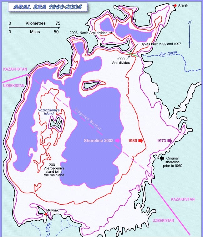
The Aral Sea was until recently the world’s fourth largest lake; in 1960 it covered 26,000 square miles (68,000 km. sq.) – an area larger than Sri Lanka. But as the waters of Tien Shan and Pamir mountains flowing down the Amu Darya and Syr Darya rivers were increasingly diverted for irrigation, the lake began to shrink. Soviet planners maximized the production of cotton and other warm-season crops, knowing that it would doom the lake. As the Aral’s waters diminished, they grew increasingly salty and foul. By the 1970s, former shoreline villages were 40 miles inland. Fish species disappeared as the lake began to die. New islands emerged, and Vozrozhdeniye Island, where the Soviets had conducted biological warfare tested, joined the mainland. When the Soviet Union collapsed, destruction accelerated. By the 1990s, the Aral Sea had been divided into two separate lakes, and by 2003, into three. In 2009, the southeastern Aral basin dried up completely.

The end of the Aral Sea brought economic and cultural devastation. Fisheries that once employed 40,000 people shut down and local agriculture suffered. As the lake retreated, large salt flats emerged. Windstorms pick up the salt, along with silt and excess agricultural chemicals, and deposit it in local farmlands. The resulting dust storms are thought to transport up to 100,000,000 tonsof particles each year. Crop yields declined and public health suffered, particularly in the densely populated and formerly rich delta of the Amu Darya River.

The tragedy of the Aral Sea is relatively well known, unlike the more recent rebirth of the Northern Aral. In 2001 the oil-rich government of Kazakhstan set about reviving what had been the much smaller of the two successor lakes. Through more efficient irrigation and the construction of modern waterworks, the flow of the lower Syr Darya River was significantly augmented. A massive dike was thrown across the lakebed to prevent the additional water from flowing wastefully across the salt flats of the former Southern Aral Sea. By early 2010, the northern lake had expanded roughly 50 percent, its salinity dropping enough to allow the return of fish. The World Bank and the government of Kazakhstan are currently considering an extension of the project, hoping to bring the lake back to the former port city of Aralsk.

The success of the North Aral restoration project should not take our eyes away from the larger disaster. The renewed Aral is a fraction of the original, and the surviving portion of the southern lake is toxically saline. Nor should we only focus on the Aral, as Central Asia has other environmentally stressed if not devastated lakes. Lop Nor was once larger that Puerto Rico; its desiccated bed later became China’s main nuclear testing ground. Massive Lake Balkhash stretches 376 miles, the distance between San Francisco and Los Angeles. Balkhash, which formed the northwestern boundary of Qing (Manchu) China at its height, is a most unusual lake — salty in the east, but essentially fresh in the west. Compared to the Aral, Balqash may be pristine, but it too is shrinking.

The Death, and Partial Rebirth, of the Aral Sea Read More »

Migration, Mining, and Insurgency in Eastern Indonesia

As we saw last Monday, a tenuous peace came to the Indonesian province of Aceh in 2005 when it was granted a special autonomous status in 2005. The same cannot be said of Papua, Indonesia’s largest province, located on the opposite side of the country. Papua was granted a measure of local autonomy in 2001, when its name was changed from “Irian Jaya.” In 2005, the Indonesian government took the further step of forming the Papuan People’s Council, composed of tribal chiefs charged with upholding local customs. Despite these measures, Papua’s long-simmering insurgency continues to generate bloodshed. In late March 2010, Papuan separatists ambushed a contingent of Indonesian soldiers in Mulia district, and in January 2010, four police officers and five civilians, including an American, were injured in a shootout in the Timika region. In July 2009, an Australian civilian was killed in Timika, a particularly restive part of Papua.

The Papuan rebellion dates back to 1965, when the OPM (Organisasi Papua Merdeka, or The Free Papua Movement) was founded to contest Indonesian control over the western half of the island of New Guinea. Indonesia gained Papua through a kind of secondary imperialism. In the late 1800s, the Dutch expanded their colonial holdings to the east of their Indonesian empire, partitioning the massive island of New Guinea with Britain and Germany. Culturally part of Melanesia, Papua had little in common with Indonesia, as the Dutch well knew. When Indonesia gained independence in 1949, the Netherlands retained western New Guinea, eventually preparing it for independence. Indonesia wanted the territory, however, and threatened to invade. The United States pressured the Netherlands to negotiate, resulting in the Indonesian military occupation of Papua in 1963, and annexation in 1969.

The Timika region is especially troubled for two reasons. First, it is the gateway to the Grasberg mine, owned mostly by Freeport McMoRan Corporation, based in Phoenix, Arizona. A massive open pit some 14,000 feet (4,500 meters) above sea level, Grasberg is the largest gold mine and third largest copper mine in the world, employing more than 19,000 people. Although Timika is situated some distance from Grasberg in the adjacent lowlands, it is the largest commercial center in the vicinity, with Papua’s largest airport (boasting a runway more than a mile long). The mine and associated businesses bring significant income to Timika, which claims the best hotel and golf course in Indonesian New Guinea. But Grasberg is also grotesquely polluting, generating 230,000 tons of tailings every day. Mine waste flows down the Aikwa River into the lowlands near Timika, where it is deposited in a broad swath of braided channels. Sedimentation and heavy metals have destroyed most of the river’s wildlife.

Timika’s second cause of strife is transmigration. The Indonesian government has long operated a huge subsidized scheme to move Javanese and Madurese peasants to the lightly populated “outer islands.” Although this official migration program was scaled back in 2000, migrants continue to pour into Papua. Roughly half of the inhabitants of the province were born in other parts of Indonesia. The city of Timika has boomed, as have the platted rural settlements in its environs (see the Google Earth images above). By 2002, Timika was large enough to host a locally infamous red-light district located ten kilometers outside town, staffed largely by Javanese immigrants. (In the pie charts in the map above, the brown areas indicated the proportions of the local populations composed of migrants.)

The indigenous people of Papua see few benefits in such developments. Many locals think that their lands and resources are being stripped away to benefit outsiders. The small measures of provincial autonomy granted by Jakarta mean little in such circumstances. As a result, the insurgency continues to simmer. The OPM is neither well funded nor well armed, however, allowing the Indonesian military to retain a firm grip on the region.

The recent violence in Timika has barely been noted in the global press. In fact, Timika itself is barely noticed by the outside world. Internet searches yield little other than information about travel arrangements, the Timika airport, and the Sheraton Hotel. Tinika does not even have a Wikipedia article of its own. Its airport does, however—a piece largely devoted to chronicling a 1996 attempt by the Indonesian military to rescue hostages held by the OPM. The operation went awry, resulting in sixteen deaths.

Migration, Mining, and Insurgency in Eastern Indonesia Read More »

Sudan: Africa’s New Breadbasket?

As yesterday’s post discussed, Ethiopia’s western lowlands have significant agricultural potential. The agricultural resources of neighboring Sudan, however, are much greater. Vast clay plains cover much of east-central and southern Sudan; although they are not easy to farm, their soils are fertile and they have abundant – often too abundant – supplies of water. With adequate investment, Sudan could become a major agricultural exporter. Foreign firms and governments are interested. The United Arab Emirates has recently leased some 400,000 hectares, and other outside interests have made similar deals. Sudan, many hope, will become the “breadbasket of the Arab world.”

One problem with this scenario is the fact that Sudan is only partially within the “Arab world”; over sixty percent of its people are not Arabs. Most of the recent land-leasing deals have been made in the largely Arabic-speaking east-central region, but the agricultural potential of non-Arab Southern Sudan is also huge. Southern Sudan, however, is a highly troubled place. Long the site of a determined rebellion against the central government that took some two million lives, it has been granted a degree of autonomy as well as the promise that it will be able to vote on actual independence in January 2011. Few outside observers expect this election to go smoothly. The Khartoum government does not want to lose this oil- and water-rich region, and the southern Sudanese themselves remain divided. Ethnic violence has been increasing over the past two years, leading the organization Refugees International to warn that Southern Sudan faces“total collapse.” Meanwhile, aid agencies are preparing for spikes in violence through much of Sudan as the country prepares for national elections next month, its first multiparty vote in 24 years.

Large-scale agricultural investment in Southern Sudan is thus unlikely in the near future. But if the region does become politically stable and if agricultural development does proceed, tensions between local people and outside investors could well be pronounced. Conflicts could also emerge between farming interests and those of wildlife conservation. The global environmental community was pleasantly shocked in 2006 when new aerial surveys in Boma National Park and elsewhere revealed vast populations of antelopes, elephants, and other species of wildlife, as it had previously been thought that the region’s long civil war had destroyed most of its fauna. “I have never seen wildlife like that, in such numbers, not even when flying over the mass migrations of the Serengeti,” reported project leader J. Michael Fay. “This could represent the biggest migration of large mammals on earth.” Southern Sudan’s government is now working to protect its newly discovered wildlife, hoping to profit from eco-tourism. Political conflict, ethnic tensions, and resource development, however, present huge obstacles.

Sudan: Africa’s New Breadbasket? Read More »

Gambella: Ethiopia’s Troubled Western Lowlands


Ethiopia is well known as a plateau country. Its cultural and political core areas have always been in the highlands. But Ethiopia also includes extensive lowlands, a legacy of the imperial conquests in the late 1800s and early 1900s. Ethnic conflicts plague much of Ethiopia’s lowland fringe, as do tensions with the central government. One of the most troubled regions is Gambella, in far western Ethiopia along the border with Sudan.

Although relatively moist and fertile, Gambella is sparsely settled, with just 300,000 people in 25,800 square kilometers. Tropical diseases and frequent flooding have historically constrained agricultural development in the region. But Gambella’s population is now booming, due largely to migration from the highlands. As many as one in five residents may be former highlanders, mostly Amhara and Oromo.

Increasing population has brought escalating tensions. The two main indigenous ethnic groups, the Nuer and the Anuak, have been fighting over land. Although speaking closely related Nilotic languages, they traditionally follow different modes of life: for the Nuer, nomadic pastoralism; for the Anuak, sedentary cultivation. As is often true in the age-old conflict between herders and farmers, the former seem to have a military advantage.

The deeper ethnic conflicts in Gambella stem from domination by the highlands. Much of the upland plateau is densely populated and short of food. As a result, sparsely settled Gambella beckons. It has good soil and plenty of water, and also boasts tungsten, platinum, gold and oil deposits. Hostility between the indigenous inhabitants and highlander immigrants intensified in recent years. In 2004, after some 400 Anuak men were reportedly killed by the Ethiopian military, Genocide Watch placed the Anuaks on its list of potential victims. Violence seems to have subsided since then, but it has by no means disappeared.

Gambella’s agricultural potential has been noticed by the world market. Ethiopia has recently leased roughly one million hectares of farmland to foreign firms, and reportedly plans to lease another two million. In Gambella, Saudi Star Agricultural Company has taken over 10,000 hectares and is expected to add another 250,000, and the Indian company Karuti Global has leased 741,000 acres. The Ethiopian government’s desire for such deals is not difficult to understand; it is an impoverished country faced with chronic hunger, whose western lowlands could produce a great deal of food. But it is also not difficult to understand local opposition. As the Anuak exile Nyikaw Ochalla reported to the Anyuak Media news site on March 2, 2010, “These are secret deals between the government and the land grabbers, in particular the foreign investors. I very much doubt that the regional government is even aware of these deals. This land grab is something that is happening in Addis Ababa, the capital city of Ethiopia. There is no consultation with the indigenous population, who remain far away from the deals. The only thing the local people see is people coming with lots of tractors to invade their lands.”

Gambella: Ethiopia’s Troubled Western Lowlands Read More »

Taiwan and the Pacific: Contracting for Recognition


On March 15, 2010, a number of newspapers announced that Taiwanese President Ma Ying-Jeou would visit his country’s allies in the South Pacific: Nauru, Kiribati, Marshall Islands, Palau, Tuvalu, and Solomon Islands. Such headlines were doubly wrong. The region specified is not exactly in the South Pacific, and the countries mentioned are not exactly allies of Taiwan.

To be sure, much of the territory of the six countries on Ma’s itinerary is in the South Pacific, but roughly 40 percent actually lies in the North Pacific (see map). This minor error is extremely common; Palau and the Marshall Island (along with the Federated States of Micronesia, Guam, and the Northern Marianas) are almost always conceptualized as being in the South Pacific, despite the fact that they are entirely north of the Equator that divides the ocean into its northern and southern halves. This unmoored usage of the term “south” stems from a time when the entire Pacific was called the South Sea (or Mer du Sud; see map above), referencing the fact that mariners usually entered the ocean from the south, sailing around the tip of South America.

Additionally, regardless of where they are situated, it is not quite accurate to describe these countries as allies of Taiwan. An ally, according to the common definition, is a “state formally cooperating with another for military or other purposes.” It is difficult to imagine Nauru, a mined-out semi-wasteland of eight square miles and fourteen thousand people, coming to the aid of Taiwan for military or any other purposes. The relationship between these countries and Taiwan is actually one of clientage rather than alliance. In essence, Nauru, Kiribati, Marshall Islands, Tuvalu, Palau, and Solomon Islands sell their diplomatic recognition to Taiwan in exchange for aid. Taiwan thereby gains a small measure of international legitimacy, while these small Pacific countries gain much needed financial resources. A couple of them have switched their recognition between Taiwan and the People’s Republic of China on several occasions, rewarding the more generous patron with their acknowledgement. Nor are they alone in the practice; Taiwan maintains the diplomatic recognition of 23 countries in total.

Nauru was once a rich little country with vast phosphate deposits. But the mines have been played out and the trust fund looted, putting Nauru in a desperate situation. Its only real resource now is diplomatic, based on its status as a recognized sovereign state. In 2009, it received $50 million from Russia in exchange for recognizing the independence of Abkhazia and South Ossetia. Such recognition may seem to mean little in practice, but it evidently has value.

Taiwan and the Pacific: Contracting for Recognition Read More »

Jiangsu and Zhejiang: The World’s Most Important Ignored Places


The standard geographical model of the world, as this blog seeks to demonstrate, unduly emphasizes the sovereign state (or “country”). States, of course, are vitally important, but so too are other geographical entities. The fixation on the independent country, compounded by the myth of continents, elevates some parts of the world while slighting others. China and India in particular are short-changed. These two are not merely large Asian countries, as France and Germany are large European countries. China and India are rather subcontinental landmasses comparable to Europe as a whole. In terms of population, they are roughly an order of magnitude larger than most other large countries, dwarfing anything in Europe. As a result, individual Chinese provinces and Indian states are comparable not to provinces of European countries, but rather to those countries in their entirety. Thus the Indian state of Maharashtra is analogous to Germany in terms of its area, population, cultural distinctiveness, and so on. Yet Maharashtra, like other Indian states, is little noticed outside of India, regarded merely as a local area within a rather monolithic country.

The slighting of first-order administrative divisions in the world’s two mega-countries is strikingly evident in the case of the Chinese provinces of Jiangsu and Zhejiang. To say that these provinces are little known in the rest of the world would be a gross understatement. Yet they are China’s two wealthiest provinces (excluding the province-level municipalities of Beijing and Shanghai; see map above). Both are slightly smaller than England in area; Zhejiang’s population (47 million) is a little less than that of England, whereas Jiangsu’s (77 million) is substantially larger. For most of the past several hundred years, northern Zhejiang and southern Jiangsu have formed the economic and, arguably, the intellectual heartland of China; today, together with Shanghai, they form one of the country’s three core areas (the other being Beijing-Tianjin in the north, and Hong Kong-Shenzhen-Guangzhou in the south). The Jiangsu-Zhejiang region is now one of the main engines of the world economy; no matter how one examines it, it is a tremendously important place. Yet outside of China, neither province receives much notice. Instead, they vanish away into an almost undifferentiated China.

The slighting of these two provinces is evidenced by their low visibility in the global media. On March 14, 2010, the indispensible Google News aggregator listed 1,377 stories containing the word “Zhejiang” and 1,365 with “Jiangsu.” These are not large numbers: a similar search for “Netherlands” (a much smaller European country) yielded 35,290 hits, while “England” (a comparable European sub-state entity) gave 166,624 returns. Asian countries of similar population also returned vastly more news articles (27,755 for Thailand). Even the smallest states in the U.S. are mentioned far more often in the news sources surveyed by Google, with Rhode Island receiving 16,271 mentions on March 14, 2010. (Note: surveying the Google news aggregator is far from perfect, as it searches for the word rather than the place; as a result, “Hunan” is somewhat over-represented due to the prevalence of “Hunan restaurants” in the United States.)

Not only are Zhejiang and Jiangsu generally overlooked in the global media, but when they are discussed the stories seldom go beyond narrow business concerns. Today’s top Google news story for Jiangsu is “AOU Submitted Application to Establish Subsidiary in Kunshan, Jiangsu,” and for Zhejiang it is “Toyota Should Compensate China Drivers, Official Says.” Areas of comparable significance in other parts of the world are generally reported on more comprehensively.

News from China, of course, is limited by China’s own restrictions on the press. But it is notable that other Chinese administrative divisions are covered much more extensively than Zhejiang and Jiangsu. The map above shows how many Google news stories were returned on March 14, 2010 for each of China’s main administrative divisions. Yunnan, Tibet and few other areas are relatively well covered; on a per capita basis, Tibet is reported on much extensively than the rest of China. The key provinces of Zhejiang and Jiangsu, however, receive scant notice.

Jiangsu and Zhejiang: The World’s Most Important Ignored Places Read More »

The Tax Haven of Norfolk Island

With just 13 square miles and 2,142 residents, Norfolk Island is not large. Lying 900 miles off Australia and 600 miles from New Zealand, it is also very remote. But Norfolk played a key role in the British colonization of the Austral realm. Extensive groves of tall, straight Norfolk Island pine (Araucaria heterophylla, now a common houseplant) carpeted the uninhabited island when James Cook happened upon it in 1774, as did thickets of New Zealand flax (Phormium tenax).The British Navy, concerned about the declining supply of masts from North America and hemp from Russia, took a deep interest in the island’s resources, contributing to the decision to found a settlement on the Australian mainland. Through the early 1800s, Norfolk maintained close contact with New South Wales; it too served as an early penal colony.

Although unpopulated when discovered by the British, Norfolk had been settled by Polynesians six to seven hundred years ago. It is not known what happened to the settlement – Norfolk was one of a number of Pacific islands that were only temporarily occupied by Polynesians. The Polynesians did leave their rat, however, along with an ecologically simplified island.

The human geography of Norfolk was transformed in 1856 with the arrival of 192 settlers from Pitcairn Island, a magnificently remote outpost east of French Polynesia. Pitcairn, a volcanic island slightly larger than Norfolk, had been settled in the late 1700s by the famous mutineers of the Bounty along with their Tahitian wives. It was not an idyll, with drunken violence decimating the men, but the population grew nonetheless. When the community threatened to outgrow Pitcairn, a contingent was relocated on Norfolk. Along with the settlers came their distinctive dialect, usually described as a blend of eighteenth-century English and Tahitian. Today the Norfolk language—Norfuk—has official status along with English on the island. Local officials fear that it is falling into disuse but are trying to encourage it. (To hear the language spoken, visit the Norfolk Language website.)

Norfolk is under the sovereign authority of Australia, but it is legally autonomous. The inhabitants have made money by doing the same thing that the legally autonomous islands attached to Britain (Man, Jersey, and Guernsey) have done: set themselves up as a tax haven. Norfolk’s government has further tried to leverage its autonomy into becoming an offshore banking center, but here it has found little success, as such moves have been resisted by the Australian government.

Norfolk controls its own immigration policy, demanding that Australians come with passports. It sometimes refuses permanent residency even to wealthy outsiders. According to the Wikipedia, Norfolk rejected singer Helen Reddy, despite her roots on the island. Norfolk’s anomalous geopolitical situation sometimes gets noticed in the North American news. In February 2010, The Vancouver Sun reported on its role in a complex legal battle over the estate of Eldon Foote, a Canadian-born entrepreneur and philanthropist, that pitted Foote’s widow and children against two charitable foundations. The heirs wanted to argue the case in a Canadian court, but the charities insisted “that Norfolk Island, a sun-drenched tax haven and self-governing territory of Australia, was the philanthropist’s legal home.” An Alberta judge ruled that this was the case, thwarting Foote’s wife and children.

Geopolitically anomalous islands – including Norfolk – occupy significant positions in the global financial order, serving as refuges from standard legal systems. Island governments take advantage of such irregularities, as do wealthy individuals and corporations. Whether the global economy as a whole gains from such stratagems is a different question.

The Tax Haven of Norfolk Island Read More »